This is the official guidebook to the Swiss section of the Via Alpina (National Route 1), published by the Swiss Hiking Federation. The Via Alpina is a network of five long-distance hiking routes which cross eight Alpine countries from Trieste to Monaco - over 5,000 kilometres of hiking trails in total. On Swiss soil, National Route 1 Via...Read more
This is the official guidebook to the Swiss section of the Via Alpina (National Route 1), published by the Swiss Hiking Federation. The Via Alpina is a network of five long-distance hiking routes which cross eight Alpine countries from Trieste to Monaco - over 5,000 kilometres of hiking trails in total. On Swiss soil, National Route 1 Via...Read more
Book of the Year Bronze Award 2010 (travel essays category), ForeWord Magazine After hiking some of the world's great trails, Brandon Wilson was excited to hear about the Via Alpina, paths running across eight countries on the backbone of the Alps. Besides promising immersion into Alpine life and wilderness, it was the ultimate adventure. It...Read more
Book of the Year Bronze Award 2010 (travel essays category), ForeWord Magazine After hiking some of the world's great trails, Brandon Wilson was excited to hear about the Via Alpina, paths running across eight countries on the backbone of the Alps. Besides promising immersion into Alpine life and wilderness, it was the ultimate adventure. It...Read more
Guidebook describing a both valley and mountain walks and treks in the Bavarian Alps. 85 walks are covered, including graded mountain routes, gentler valley walks, hut-to-hut routes and two multi-day tours, arranged by region with practical information on transport, accommodation and the like. Since the last edition of this guide many of the...Read more
Guidebook describing a both valley and mountain walks and treks in the Bavarian Alps. 85 walks are covered, including graded mountain routes, gentler valley walks, hut-to-hut routes and two multi-day tours, arranged by region with practical information on transport, accommodation and the like. Since the last edition of this guide many of the...Read more
Book of the Year Bronze Award 2010 (travel essays category), ForeWord Magazine After hiking some of the world's great trails, Brandon Wilson was excited to hear about the Via Alpina, paths running across eight countries on the backbone of the Alps. Besides promising immersion into Alpine life and wilderness, it was the ultimate adventure. It...Read more
Book of the Year Bronze Award 2010 (travel essays category), ForeWord Magazine After hiking some of the world's great trails, Brandon Wilson was excited to hear about the Via Alpina, paths running across eight countries on the backbone of the Alps. Besides promising immersion into Alpine life and wilderness, it was the ultimate adventure. It...Read more
zahlr. Touren mit Top-Routenkarten und HöhenprofilenDe Kompass wandelgids + kaart geeft een overzicht van alle wandelroutes in het gebied met nauwkeurige routeaanwijzingen en hoogteaanduidingen, De extra grote kaart, schaal 1:35 000, is ideaal om van te voren uw route uit te stippelen en om onderweg te gebruiken • naast de bekende bestemmingen,...Read more
zahlr. Touren mit Top-Routenkarten und HöhenprofilenDe Kompass wandelgids + kaart geeft een overzicht van alle wandelroutes in het gebied met nauwkeurige routeaanwijzingen en hoogteaanduidingen, De extra grote kaart, schaal 1:35 000, is ideaal om van te voren uw route uit te stippelen en om onderweg te gebruiken • naast de bekende bestemmingen,...Read more
De Kompass wandelgids + kaart geeft een overzicht van alle wandelroutes in het gebied met nauwkeurige routeaanwijzingen en hoogteaanduidingen, De extra grote kaart, schaal 1:35 000, is ideaal om van te voren uw route uit te stippelen en om onderweg te gebruiken; naast de bekende bestemmingen, worden ook de minder bekende vermeld; openbaar...Read more
De Kompass wandelgids + kaart geeft een overzicht van alle wandelroutes in het gebied met nauwkeurige routeaanwijzingen en hoogteaanduidingen, De extra grote kaart, schaal 1:35 000, is ideaal om van te voren uw route uit te stippelen en om onderweg te gebruiken; naast de bekende bestemmingen, worden ook de minder bekende vermeld; openbaar...Read more
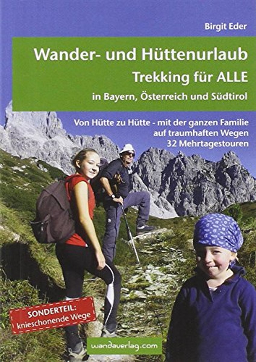
Von Hütte zu Hütte mit leichtem Gepäck zu wandern, ist eine wunderbare Art, dem Alltag zu entfliehen. Die spannenden Mehrtagestouren sind in leicht zu bewältigende Etappen unterteilt, die nach Kondition oder Laune zusammengefasst werden können. Darum ist dieser Trekkingführer für EinsteigerInnen wie für Versierte gleichermaßen eine Fundgrube....Read more
Von H tte zu H tte mit leichtem Gep ck zu wandern, ist eine wunderbare Art, dem Alltag zu entfliehen. Die spannenden Mehrtagestouren sind in leicht zu bew ltigende Etappen unterteilt, die nach Kondition oder Laune zusammengefasst werden k nnen. Darum ist dieser Trekkingf hrer f r EinsteigerInnen wie f r Versierte gleicherma en eine Fundgrube....Read more
Von H tte zu H tte mit leichtem Gep ck zu wandern, ist eine wunderbare Art, dem Alltag zu entfliehen. Die spannenden Mehrtagestouren sind in leicht zu bew ltigende Etappen unterteilt, die nach Kondition oder Laune zusammengefasst werden k nnen. Darum ist dieser Trekkingf hrer f r EinsteigerInnen wie f r Versierte gleicherma en eine Fundgrube....Read more
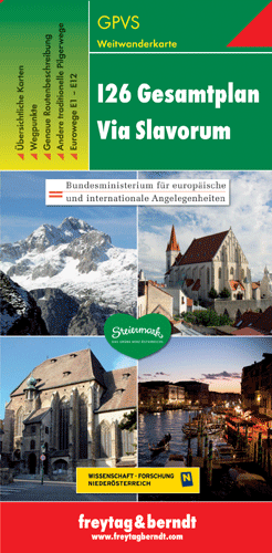
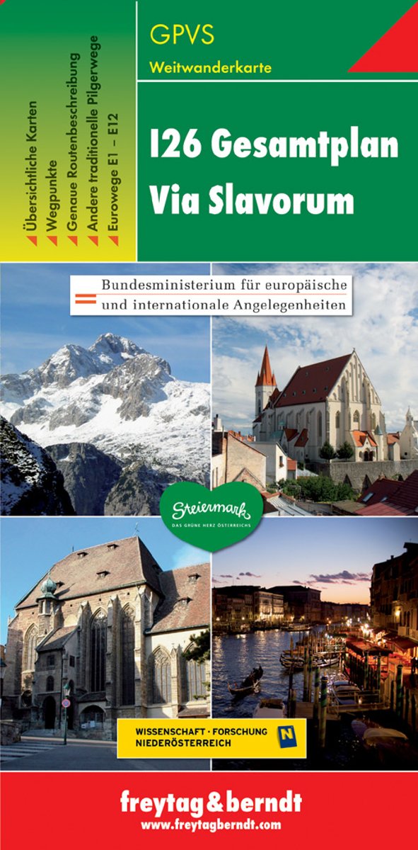
Dit is een overzichtskaart van de wandelkaart en/of pelgrimskaart voor de Via Slavorum, de internationale pelgrimsweg I26 die dwars door Midden-en Zuid-Europa voert: Van Krakau in Polen - Brno / Brünn in Tsjechië - Wenen, Mariazell, Graz, Klagefurt in Oostenrijk (Neder-Oostenrijk, Steiermark en Karinthie) - door het Save en Isonzodal in...Read more
Dubbelzijdige wandel- en vrijetijdskaart toeristische tips stadsplattegronden overzichtskaart van de pelgrimsroute Via Slavorum, de internationale pelgrimsweg I26 die dwars door Midden- en Zuid-Europa voert GPS-puntenRead more
Dubbelzijdige wandel- en vrijetijdskaart toeristische tips stadsplattegronden overzichtskaart van de pelgrimsroute Via Slavorum, de internationale pelgrimsweg I26 die dwars door Midden- en Zuid-Europa voert GPS-puntenRead more