Madeira on a double-sided, indexed, hiking map from Freytag & Berndt at 1:30,000 with prominent highlighting for walking routes, scenic roads, picturesque locations and places of interest, plus a street plan of central Funchal and a booklet with general notes about the island and brief descriptions of seven recommended hiking routes. Place...Read more
Toeristische kaart voor wandelen, fietsen en vrije tijd met activiteitengids en stadsplattegronden goed leesbare schaal van 1:50 000 te gebruiken met GPS met praktische informatie over de regio wandel- en fietspaden aanbevolen routes kastelen uitzichtpunten stranden en baaien toeristische informatie veel topografische...Read more
Toeristische kaart voor wandelen, fietsen en vrije tijd met activiteitengids en stadsplattegronden goed leesbare schaal van 1:50 000 te gebruiken met GPS met praktische informatie over de regio wandel- en fietspaden aanbevolen routes kastelen uitzichtpunten stranden en baaien toeristische informatie veel topografische...Read more
Toeristische kaart voor wandelen, fietsen en vrije tijd met activiteitengids en stadsplattegronden; goed leesbare schaal van 1:50 000; te gebruiken met GPS; met praktische informatie over de regio; wandel- en fietspaden; aanbevolen routes; kastelen; uitzichtpunten; stranden en baaien; toeristische informatie; veel topografische details; DuitstaligRead more
Toeristische kaart voor wandelen, fietsen en vrije tijd met activiteitengids en stadsplattegronden; goed leesbare schaal van 1:50 000; te gebruiken met GPS; met praktische informatie over de regio; wandel- en fietspaden; aanbevolen routes; kastelen; uitzichtpunten; stranden en baaien; toeristische informatie; veel topografische details; DuitstaligRead more
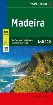
Madeira on a large, indexed, touring and sightseeing map from Freytag & Berndt at 1:40,000 with prominent highlighting for scenic roads, hiking routes, picturesque locations and places of interest, plus a street plan of central Funchal and a booklet with descriptions of best sights, etc. Place names and road numbers are in larger size font than...Read more
Topographic survey of Portugal at 1:25,000 from the Instituto Geográfico do Exército, the country’s military survey organisation.Map legend and a glossary of terms used on the maps include English.To see all the titles in this series please click on the series link.Read more
Topographic survey of Portugal at 1:25,000 from the Instituto Geográfico do Exército, the country’s military survey organisation.Map legend and a glossary of terms used on the maps include English.To see all the titles in this series please click on the series link.Read more
Plans included:Porto Santo (1:25 000)Porto de Recreio da Calheta (1:6250)Funchal (1:10 000)Água de Pena (1:5000)Porto de Machico (1:7500)Quinta do Lorde (1:5000)Ponta de São Lourenço (1:30 000)Enseada da Doca (Isla Deserta Grande) (1:25 000)Selvagem Grande (1:30 000)Selvagem Pequena (1:30 000)On this edition the chart specification has been...Read more