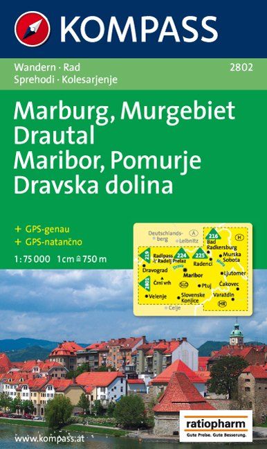
Maribor - Pomurje and the Drava Valley in a series of GPS compatible, double-sided recreational maps at 1:75,000 from Kompass covering Northern Slovenia and the countryRead more
Maribor - Pomurje and the Drava Valley in a series of GPS compatible, double-sided recreational maps at 1:75,000 from Kompass covering Northern Slovenia and the country’s coast, with hiking and cycling routes plus extensive tourist information. Cartography, different in style to that used in Kompass’s extensive hiking series covering other...Read more
Stajerska region of north-eastern Slovenia on a contoured and GPS compatible map at 1:50,000 from the Ljubljana-based Kartografija, with coverage centred on Ptuj and including Maribor on the western edge of the map. On the reverse are bilingual English/Slovenian descriptions of the region’s best sights.Maps in this series from Kartografija,...Read more
Pomurje in a series of double-sided maps at 1:40,000 from Kartografija in Ljubljana, accompanied by bilingual guides with descriptions of hiking trails, cycling routes, places of interest, lists of mountain huts, etc.The maps have contours at 20m intervals, enhanced by relief shading and graphics to provide a very effective picture of the...Read more
Ljubljana and Environs in a series of double-sided maps at 1:40,000 from Kartografija in Ljubljana, accompanied by bilingual guides with descriptions of hiking trails, cycling routes, places of interest, lists of mountain huts, etc.The maps have contours at 20m intervals, enhanced by relief shading and graphics to provide a very effective...Read more
Notranjski Kras, Brkini, Dolenjska and Bela Krajina regions of southern Slovenia on a contoured and GPS compatible map at 1:75,000 from the Ljubljana-based Kartografija. The map is double-sided and includes bilingual English/Slovenian descriptions of the region’s best sights.Maps in this series from Kartografija, covering most of Slovenia at...Read more
Polhograjsko Hribovje area at 1:25,000 in a series of contoured, GPS compatible recreational maps from Planinska zveza Slovenie - Slovenian Alpine Club, covering Slovenia’s popular hiking regions at 1:50,000 or 1:25,000. Contours are at 20m intervals and the map has a 1km UTM grid plus 1’ margin ticks. On the reverse are details of two mountain...Read more
Ljubljana and Environs on a contoured and GPS compatible map at 1:75,000 from the Ljubljana-based Kartografija. On the reverse are bilingual English/Slovenian descriptions of the region’s best sights.Maps in this series from Kartografija, covering most of Slovenia at 50K or 75K, have contours at 20m intervals, enhanced by relief shading and...Read more