De Zwerver
Netherlands

Stanfords
United Kingdom
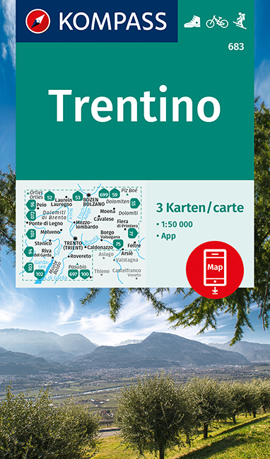
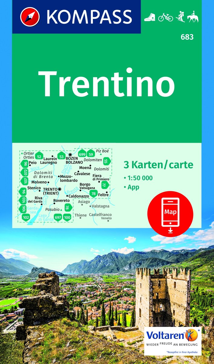
- Trentino 3-Map Set Kompass 683
- Trentino region of Italy on a set of three double-sided, GPS compatible and contoured maps at 1:50,000 from Kompass, with hiking trails, cycling, ski and horse riding routes, various recreational facilities, etc. The set provides very wide coverage of this popular part of Italy, extending from north of Bolzano southwards to include the northern... Read more

De Zwerver
Netherlands
Stanfords
United Kingdom
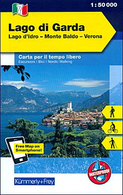
- Lake Garda - Lake Idro - Monte Baldo - Verona K+F Outdoor Map 7
- Lake Garda - Lake d`Idro - Monte Baldo - Verona area at 1:50,000 in a series of waterproof and tear-resistant, GPS compatible and contoured recreational maps from Kümmerly + Frey with both local and long-distance hiking and cycling trails, ski routes, sites for other outdoor pursuits, accommodation, bus stops, etc. An inset provides a small... Read more

De Zwerver
Netherlands
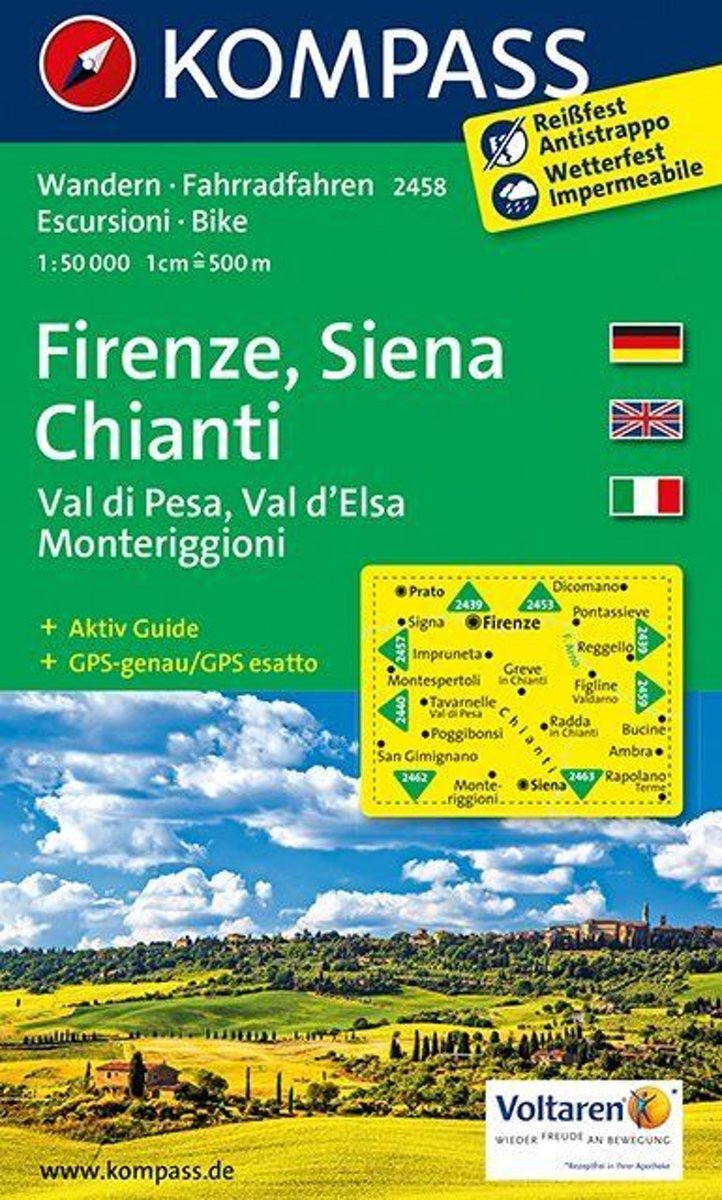
- Wandelkaart 2458 Firenze - Siena - Chianti | Kompass
- Florence - Siena - Chianti area on a double-sided map at 1:50,000 from Kompass, printed on durable, waterproof and tear-resistant synthetic paper. Coverage includes Val di Pesa, Val d’Elsa, Monteriggioni, etc. Contours are at 40m intervals, with a 2-km UTM grid. Extensive overprint includes GEA - Grande Escursione Appenninica, Sentiero Italia,... Read more

Stanfords
United Kingdom
- Florence - Siena - Chianti Kompass 2458
- Florence - Siena - Chianti area on a double-sided map at 1:50,000 from Kompass, printed on durable, waterproof and tear-resistant synthetic paper. Coverage includes Val di Pesa, Val d’Elsa, Monteriggioni, etc. Contours are at 40m intervals, with a 2-km UTM grid. Extensive overprint includes GEA - Grande Escursione Appenninica, Sentiero Italia,... Read more
Bol.com
Netherlands
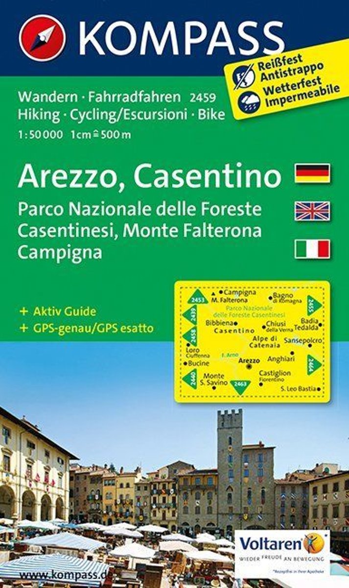
- Arezzo, Casentino WK 2459
- Deze kaart is ideaal voor het uitstippelen van wandel- en fietsroutes en om onderweg te gebruiken • goed leesbare kaart met heel veel topografische details • duidelijke symbolen maken de kaart extra overzichtelijk • wandel- en fietsroutes zijn aangegeven • praktische informatie over de regio • bruikbaar met GPS • nuttige informatie voor... Read more
Bol.com
Belgium
- Arezzo, Casentino WK 2459
- Deze kaart is ideaal voor het uitstippelen van wandel- en fietsroutes en om onderweg te gebruiken • goed leesbare kaart met heel veel topografische details • duidelijke symbolen maken de kaart extra overzichtelijk • wandel- en fietsroutes zijn aangegeven • praktische informatie over de regio • bruikbaar met GPS • nuttige informatie voor... Read more
Bol.com
Netherlands
- Florence, Siena, Chianti WK2458
- Deze kaart is ideaal voor het uitstippelen van wandel- en fietsroutes en om onderweg te gebruiken • goed leesbare kaart met heel veel topografische details • duidelijke symbolen maken de kaart extra overzichtelijk • wandel- en fietsroutes zijn aangegeven • praktische informatie over de regio • bruikbaar met GPS • nuttige informatie voor... Read more
Bol.com
Belgium
- Florence, Siena, Chianti WK2458
- Deze kaart is ideaal voor het uitstippelen van wandel- en fietsroutes en om onderweg te gebruiken • goed leesbare kaart met heel veel topografische details • duidelijke symbolen maken de kaart extra overzichtelijk • wandel- en fietsroutes zijn aangegeven • praktische informatie over de regio • bruikbaar met GPS • nuttige informatie voor... Read more
Bol.com
Netherlands
- Trentino 1:50 000
- -Die Provinz Trentino erstreckt sich vom Tonalepass im Westen bis zur Pala-Gruppe bei San Martino di Castrozza im Osten. In der Nord-Süd-Ausdehnung reicht sie von Canazei im Norden und im Süden bis zum Gardasee.-Geprägt wird die östliche Trentino-Region durch einzeln stehende Kalkmassive wie Pala- und Sellagruppe, Latemar-Rosengarten, Marmolata... Read more
Bol.com
Belgium
- Trentino 1:50 000
- -Die Provinz Trentino erstreckt sich vom Tonalepass im Westen bis zur Pala-Gruppe bei San Martino di Castrozza im Osten. In der Nord-Süd-Ausdehnung reicht sie von Canazei im Norden und im Süden bis zum Gardasee.-Geprägt wird die östliche Trentino-Region durch einzeln stehende Kalkmassive wie Pala- und Sellagruppe, Latemar-Rosengarten, Marmolata... Read more
Bol.com
Netherlands
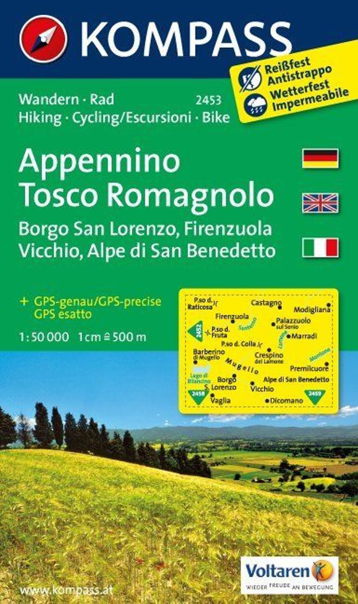
- Appennino Tosco-Romagnolo WK2453
- Deze kaart is ideaal voor het uitstippelen van wandel- en fietsroutes en om onderweg te gebruiken • goed leesbare kaart met heel veel topografische details • duidelijke symbolen maken de kaart extra overzichtelijk • wandel- en fietsroutes zijn aangegeven • praktische informatie over de regio • bruikbaar met GPS • nuttige informatie voor... Read more
Bol.com
Belgium
- Appennino Tosco-Romagnolo WK2453
- Deze kaart is ideaal voor het uitstippelen van wandel- en fietsroutes en om onderweg te gebruiken • goed leesbare kaart met heel veel topografische details • duidelijke symbolen maken de kaart extra overzichtelijk • wandel- en fietsroutes zijn aangegeven • praktische informatie over de regio • bruikbaar met GPS • nuttige informatie voor... Read more

Stanfords
United Kingdom
- Prato Province Hiking Routes
- The province of Prato, just north-west of Florence, on a double-sided, contoured and GPS compatible map at 1:25,000 from Edizioni Multigraphic highlighting waymarked routes and other hiking paths, with access by public transports, etc.The map has contours at 20m intervals with relief shading and plenty of spot heights. Hiking paths are... Read more

Stanfords
United Kingdom
- Siena - Volterra - Massa Marittima - Roccastrada Kompass 2462
- Siena - Volterra - Massa Marittima - Rocca Strada map at 1:50,000 from Kompass, printed on durable, waterproof and tear-resistant synthetic paper. Coverage includes Colle di Va d’Elsa, Casole d’Elsa, Metallifere hills, etc. Contours are at 40m intervals, with a 2-km UTM grid. Extensive overprint includes GEA - Grande Escursione Appenninica,... Read more

Stanfords
United Kingdom
- Monti Nebrodi
- Parco Naturale dei Monti Nebrodi on the northern coast of Sicily on a contoured and GPS compatible map at 1:50,000 from Litografia Artistica Cartografica in their Global Map imprint, highlighting hiking trails plus various facilities and/or places of interest in and around the park.Topography is shown by contours at 25m intervals with light... Read more

Stanfords
United Kingdom
- Monti Sibillini National Park Edizioni Multigraphic 60/61
- Monti Sibillini National Park at 1:25,000 on a double-sided contoured map from Edizioni Multigraphic highlighting local waymarked hiking routes including the GAS – Grand Anello dei Sibilini, the circular tour around the mountains.The map has contours at 25m intervals with colouring for woodlands. Waymarked routes are highlighted and annotated... Read more

Stanfords
United Kingdom
- Val Venosta / Vinschgau K+F Outdoor Map 1
- Val Venosta / Vinschgau area in the Dolomites at 1:50,000 in a series of waterproof and tear-resistant, GPS compatible and contoured recreational maps from Kümmerly + Frey with both local and long-distance hiking and cycling trails, ski routes, sites for other outdoor pursuits, accommodation, bus stops, etc. Coverage includes the Ortles/Ortler... Read more

Stanfords
United Kingdom
- Parco delle Madonie
- Parco delle Madonie on the north coast of Sicily just south of Cefalù on a detailed, GPS compatible map at 1:50,000 from LAC in their Globalmap imprint. An overprint highlights hiking trails, including the local section of Sentiero Italia, and indicates more strenuous sections.Topography of this interesting area is very well presented by... Read more

Stanfords
United Kingdom
- Monti Sibillini National Park 6-Map Set
- Monti Sibillini National Park in a 6 sheet set, contoured and GPS compatible map at 1:25,000 published by Societá Editrice Ricerche. The maps highlight hiking trails, including the Grande Anello dei Monti Sibilini long-distance circuit.Modern cartography from the Italian topographic survey has contours at 20m intervals, relief shading, and... Read more

Stanfords
United Kingdom
- Lake Maggiore - Lake Orta - Lake Varese K+F Outdoor Map 8
- Lake Maggiore - Lake Orta - Lake Varese area at 1:50,000 in a series of waterproof and tear-resistant, GPS compatible and contoured recreational maps from Kümmerly + Frey with both local and long-distance hiking and cycling trails, ski routes, sites for other outdoor pursuits, accommodation, bus stops, etc. An inset provides a small road map of... Read more