
Oosterschelde
Beschrijving
In 1953 the North Sea flooded large parts of the south-west of the Netherlands, the province of Zeeland. Since then, this river delta has been protected by immense dykes, dams and flood barriers. One large water inlet, the Oosterschelde, was on the list to get cut off from the sea. This would mean the loss of a gigantic salt water biotope with all its animals, seelife, birdlife. It was decided to have a flood barrier build instead of a dam, a very expensive solution. Nowadays, the Oosterschelde is more beautifull than ever before.
Paden in deze regio
Links
Feiten
Verslagen
Gidsen en kaarten
Overnachting
Organisaties
Reisorganisaties
GPS
Anders
Boeken
De Zwerver
Netherlands
2019
Netherlands
2019
.jpg)
De Zwerver
Netherlands
2013
Netherlands
2013
- Wandelgids 5-3 LAW Nederlands Kustpad deel 3, Friesland-Groningen | Wandelnet
- Helder vormgegeven wandelgids met bijzonder duidelijke topografische kaarten. Met openbaar vervoer informatie. In deze gids zijn twee Lange-Afstand-Wandelpaden gecombineerd tot een doorlopende route : het Friese Kustpad en het Wad- en Wierdenpad. Ook zijn tien dagwandelingen opgenomen. Het Nederlands Kustpad deel 3, Friesland - Groningen maakt... Read more
De Zwerver
Netherlands
2014
Netherlands
2014
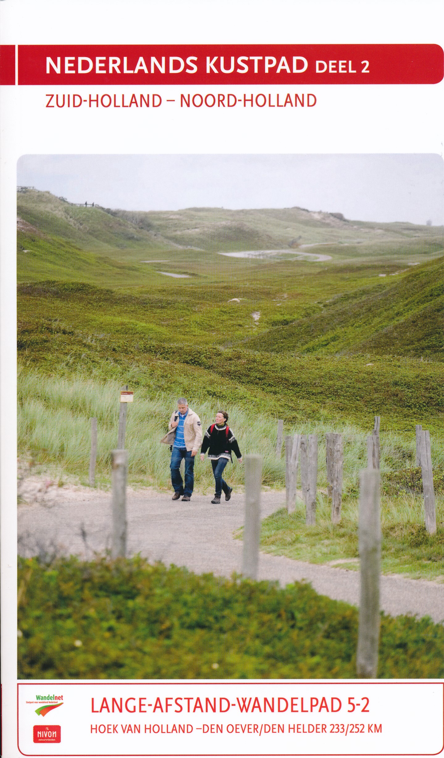
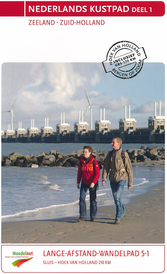
- Wandelgids 5-1 LAW Nederlands Kustpad deel 1 | Wandelnet
- Deze wandelgids van het Lange-Afstand-Wandelpad van Sluis (Zeeland) naar Hoek van Holland (Zuid-Holland) en een variant van Bergen op Zoom (Noord-Brabant) naar Hoek van Holland is een meerdaagse wandelroute en is herkenbaar aan de wit-rode markering langs de route. Naast een bondige en duidelijke routebeschrijving en gedetailleerde... Read more

De Zwerver
Netherlands
Netherlands
- Also available from:
- Stanfords, United Kingdom

Stanfords
United Kingdom
United Kingdom
- Birmingham, Wolverhampton & The Black Country OS Landranger Map 139 (paper)
- Birmingham with the surrounding area including the Black Country, Wolverhampton, Walsall, Solihull, Stourbridge, Bromsgrove and a section of the E2 European Long-distance Path on a paper version of map No. 139 from the Ordnance Survey’s Landranger series at 1:50,000, with contoured and GPS compatible topographic mapping plus tourist... Read more

De Zwerver
Netherlands
Netherlands
- Also available from:
- Stanfords, United Kingdom

Stanfords
United Kingdom
United Kingdom
- Kettering, Corby, Market Harborough & Stamford OS Landranger Map 141 (paper)
- The area around Kettering, Corby, Market Harborough and Stamford, including Rockingham Forest and part of the E2 European Long-distance Path, on a paper version of map No. 141 from the Ordnance Survey’s Landranger series at 1:50,000, with contoured and GPS compatible topographic mapping plus tourist information.MOBILE DOWNLOADS: As well as the... Read more

De Zwerver
Netherlands
Netherlands
- Also available from:
- Stanfords, United Kingdom

Stanfords
United Kingdom
United Kingdom
- Reading & Windsor - Henley-on-Thames & Bracknell OS Landranger Map 175 (paper)
- Reading – Windsor area, including a section of the Thames Path / E2 European Long-distance Path, on a paper version of map No. 175 from the Ordnance Survey’s Landranger series at 1:50,000, with contoured and GPS compatible topographic mapping plus tourist information.MOBILE DOWNLOADS: As well as the physical edition of the map, each Landranger... Read more
De Zwerver
Netherlands
2017
Netherlands
2017
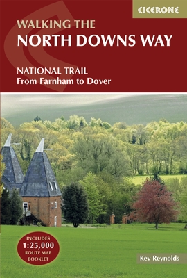
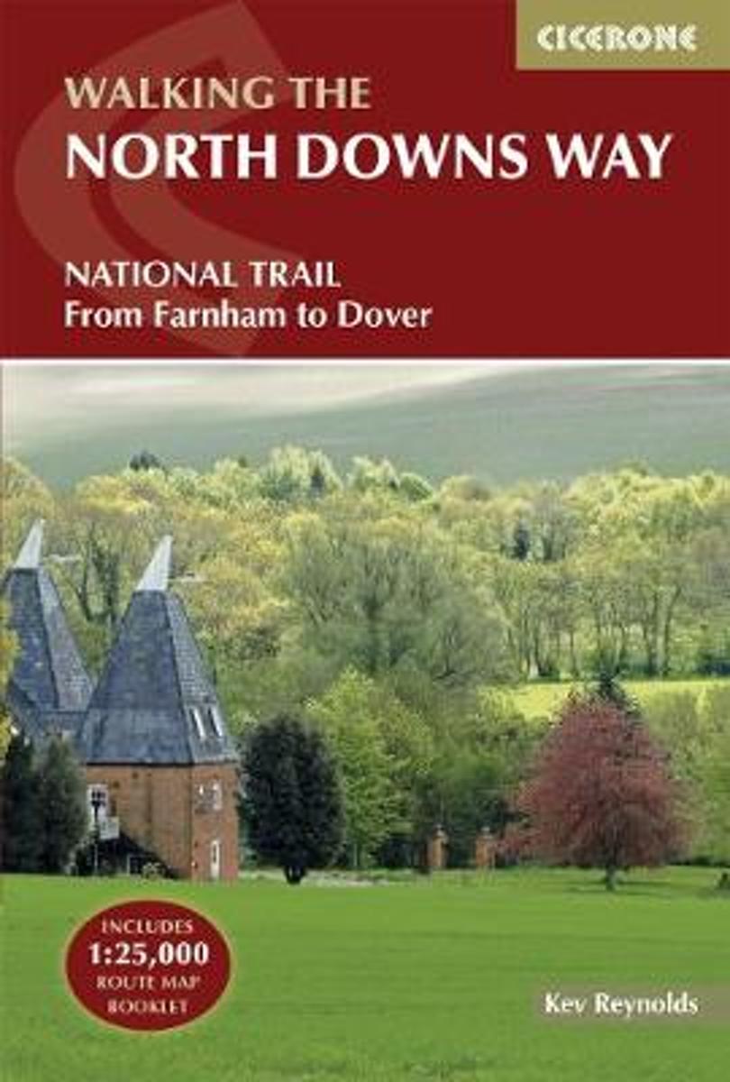
- Wandelgids The North Downs Way | Cicerone
- Guidebook to walking the North Downs Way National Trail, a 130 mile (208km) trail between Farnham and Dover, with an optional visit to Canterbury. Following the ancient Pilgrim's Way for much of the way, through pleasant countryside, this is one of the easier National Trails and the walk is described over 11 stages. With 1:25K OS map booklet. Read more
- Also available from:
- Bol.com, Netherlands
- Bol.com, Belgium
- Stanfords, United Kingdom
- The Book Depository, United Kingdom
Bol.com
Netherlands
2017
Netherlands
2017
- The North Downs Way
- The North Downs Way National Trail is a 130 mile (208km) between the high downland of Farnham and the historic city of Dover on the Kent coast. The route is described in 11 day stages from west to east with an optional detour via Canterbury. Step-by-step route descriptions are fully illustrated with colour photographs and extracts from OS... Read more
Bol.com
Belgium
2017
Belgium
2017
- The North Downs Way
- The North Downs Way National Trail is a 130 mile (208km) between the high downland of Farnham and the historic city of Dover on the Kent coast. The route is described in 11 day stages from west to east with an optional detour via Canterbury. Step-by-step route descriptions are fully illustrated with colour photographs and extracts from OS... Read more

Stanfords
United Kingdom
2017
United Kingdom
2017
- The North Downs Way
- A guidebook to walking the North Downs Way National Trail, a 130 mile (208km) walk between the high downland of Farnham and the historic city of Dover on the Kent coast, with an optional visit to Canterbury. The route is described in 11 stages, and is fully illustrated with colour photographs and OS map extracts. The North Downs Way is one of... Read more

The Book Depository
United Kingdom
2017
United Kingdom
2017
- The North Downs Way
- National Trail from Farnham to Dover Read more
Bol.com
Netherlands
Netherlands
- Wad- en WierdenpadL LAW 5 Lauwersoog - Nieuweschans
- Wandelen in het zeekleigebied van Noord-Groningen. Deze wandeling biedt een kennismaking met de vele karakteristieke landschapselementen die herinneren aan de omgang met het water, o.a. dijken, restanten van oude zeegeulen, wierden en sluizen. Het Noord-Groningse landschap is voor wie niet uit deze omgeving komt verrassend. Vergezichten in het... Read more
- Also available from:
- Bol.com, Belgium
Bol.com
Belgium
Belgium
- Wad- en WierdenpadL LAW 5 Lauwersoog - Nieuweschans
- Wandelen in het zeekleigebied van Noord-Groningen. Deze wandeling biedt een kennismaking met de vele karakteristieke landschapselementen die herinneren aan de omgang met het water, o.a. dijken, restanten van oude zeegeulen, wierden en sluizen. Het Noord-Groningse landschap is voor wie niet uit deze omgeving komt verrassend. Vergezichten in het... Read more
De Zwerver
Netherlands
2006
Netherlands
2006
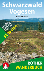
- Wandelgids Schwarzwald - Vogesen | Rother Bergverlag
- Uitstekende wandelgids van het Zwarte Woud en een deel van de Vogezen. Nauwkeurig beschreven met praktische info per tocht. De ‘Rother Wanderbücher’ behandelen telkens de 50 mooiste wandelingen, die variëren van eenvoudige kindvriendelijke wandelingen tot routes die aanzienlijk meer ervaring vereisen. Uitvoerige routebeschrijvingen, een... Read more
- Also available from:
- Bol.com, Netherlands
- Bol.com, Belgium
Bol.com
Netherlands
2006
Netherlands
2006
- Schwarzwald - Vogesen
- Die schönsten und spannendsten Wanderberge im Schwarzwald und in den Vogesen präsentiert dieser Führer in einer Auswahl von 50 Wandervorschlägen für jede Kondition. Vom alpinen Steig am Feldberg, der höchsten Erhebung der deutschen Mittelgebirge, spannt sich der Bogen bis zum Grand Ballon, dem höchsten Berg der Vogesen, vom Belchen als dem... Read more
Bol.com
Belgium
2006
Belgium
2006
- Schwarzwald - Vogesen
- Die schönsten und spannendsten Wanderberge im Schwarzwald und in den Vogesen präsentiert dieser Führer in einer Auswahl von 50 Wandervorschlägen für jede Kondition. Vom alpinen Steig am Feldberg, der höchsten Erhebung der deutschen Mittelgebirge, spannt sich der Bogen bis zum Grand Ballon, dem höchsten Berg der Vogesen, vom Belchen als dem... Read more
Bol.com
Netherlands
Netherlands
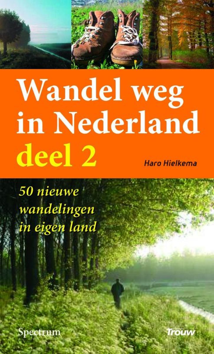
- Wandel Weg In Nederland
- Wandel weg in eigen land Vijftig nieuwe en verrassende wandelroutes. De vijftig unieke wandelroutes in dit boek vormen een selectie uit de wandelingen die Haro Hielkema de afgelopen jaren voor dagblad Trouw maakte. Niet de afstand of de prestatie staat bij deze tochten voorop, maar het verhaal achter het landschap, het genieten van het... Read more
- Also available from:
- Bol.com, Belgium
Bol.com
Belgium
Belgium
- Wandel Weg In Nederland
- Wandel weg in eigen land Vijftig nieuwe en verrassende wandelroutes. De vijftig unieke wandelroutes in dit boek vormen een selectie uit de wandelingen die Haro Hielkema de afgelopen jaren voor dagblad Trouw maakte. Niet de afstand of de prestatie staat bij deze tochten voorop, maar het verhaal achter het landschap, het genieten van het... Read more
Bol.com
Netherlands
Netherlands
- More Baskets And How To Make Them
- More Baskets AND How to Make Them MARY WHITE a Author of How to Make Baskets Illustrated from photographs, and drawings by the author GARDEN CITY NEW YORK DOUBLEDAY, PAGE COMPANY 1916 MORE BASKETS AND HOW TO MAKE THEM z - -2 1 r i c 5 Z c 2 L - L v 2 y T .C I n C C 2 2s - L M CLC g .E 2 Copyright. 1903, by Doubleday, Page Cornpant Publirhtd,... Read more
- Also available from:
- Bol.com, Belgium
Bol.com
Belgium
Belgium
- More Baskets And How To Make Them
- More Baskets AND How to Make Them MARY WHITE a Author of How to Make Baskets Illustrated from photographs, and drawings by the author GARDEN CITY NEW YORK DOUBLEDAY, PAGE COMPANY 1916 MORE BASKETS AND HOW TO MAKE THEM z - -2 1 r i c 5 Z c 2 L - L v 2 y T .C I n C C 2 2s - L M CLC g .E 2 Copyright. 1903, by Doubleday, Page Cornpant Publirhtd,... Read more

De Zwerver
Netherlands
Netherlands
- Also available from:
- Bol.com, Netherlands
- Bol.com, Belgium
- Stanfords, United Kingdom
- The Book Depository, United Kingdom

Bol.com
Netherlands
Netherlands
- Purbeck & South Dorset, Poole, Dorchester, Weymouth & Swanage
- OS Explorer is the Ordnance Survey's most detailed map and is recommended for anyone enjoying outdoor activities like walking, horse riding and off-road cycling. The OS Explorer range of OL maps now includes a digital version of the paper map, accessed through the OS smartphone app, OS Maps. Providing complete GB coverage the series details... Read more
Bol.com
Belgium
Belgium
- Purbeck & South Dorset, Poole, Dorchester, Weymouth & Swanage
- OS Explorer is the Ordnance Survey's most detailed map and is recommended for anyone enjoying outdoor activities like walking, horse riding and off-road cycling. The OS Explorer range of OL maps now includes a digital version of the paper map, accessed through the OS smartphone app, OS Maps. Providing complete GB coverage the series details... Read more

Stanfords
United Kingdom
United Kingdom
- Purbeck & South Dorset - Poole, Dorchester - Weymouth & Swanage OS Explorer Map OL15 (paper)
- Purbeck and the southern part of Dorset on a detailed topographic and GPS compatible map OL15, paper version, from the Ordnance Survey’s 1:25,000 Explorer series. Coverage extends from Poole and Swanage in the east to Bridport in the west, and includes Dorchester, Tolpuddle, Bere Regis, Wareham, Weymouth, Chesil Beach, Portland Bill, the final... Read more

The Book Depository
United Kingdom
United Kingdom

Stanfords
United Kingdom
United Kingdom
- Bury St Edmunds, Sudbury & Stowmarket OS Landranger Active Map 155 (waterproof)
- Suffolk around Bury St Edmunds, Sudbury and Stowmarket, including part of the E2 European Long-distance path, on a waterproof and tear-resistant OS Active version of map No. 155 from the Ordnance Survey’s Landranger series at 1:50,000, with contoured and GPS compatible topographic mapping plus tourist information.MOBILE DOWNLOADS: As well as... Read more

Stanfords
United Kingdom
United Kingdom
- Eastbourne, Hastings, Crowborough, Battle & Heathfield OS Landranger Active Map 199 (waterproof)
- Eastbourne and Hastings area, including the Seven Sisters and sections of the South Downs Way and the E9 European Long-distance Path, on a waterproof and tear-resistant OS Active version of map No. 199 from the Ordnance Survey’s Landranger series at 1:50,000, with contoured and GPS compatible topographic mapping plus tourist information.MOBILE... Read more
Kaarten

De Zwerver
Netherlands
Netherlands
- Wandelkaart - Fietskaart Insel Rügen | Verlag Dr. Barthel
- Frei von Werbeanzeigen. reißfest, wetterfest durch Beschichtung mit hochwertiger nicht spiegelnder Folie, mit ausgewählten Straßennamen zur besseren Orientierung, farbig hervorgehobenen Ausflugszielen, Sehenswürdigkeiten der Umgebung in Text und Bild und alle regionalen und überregionalen Wander- und Radwanderwege sowie ausgewiesene... Read more

De Zwerver
Netherlands
Netherlands
- Wandelkaart WKE2 La Palma | Freytag & Berndt
- Uitstekende wandelkaart van La Palma, tweezijdig, met ingetekende routes, hoogtelijnen en andere belangrijke informatie. Ook met fietsroutes, bovendien GPS geschikt! Read more
- Also available from:
- Bol.com, Netherlands
- Bol.com, Belgium
- The Book Depository, United Kingdom

Bol.com
Netherlands
Netherlands
- FB WKE2 La Palma
- Dubbelzijdige wandel- en vrijetijdskaart • toeristische tips • stadsplattegronden • fietspaden en mountainbikeroutes • GPS-punten • ski- en langlaufroutes Read more
Bol.com
Belgium
Belgium
- FB WKE2 La Palma
- Dubbelzijdige wandel- en vrijetijdskaart • toeristische tips • stadsplattegronden • fietspaden en mountainbikeroutes • GPS-punten • ski- en langlaufroutes Read more

The Book Depository
United Kingdom
United Kingdom
- La Palma Hiking + Leisure Map 1:30 000
- Uitstekende wandelkaart van La Palma, tweezijdig, met ingetekende routes, hoogtelijnen en andere belangrijke informatie. Ook met fietsroutes, bovendien GPS geschikt! Read more

Stanfords
United Kingdom
United Kingdom
- NL5 Ooster en Westerschelde
- Passage ChartsC1 Zuidelijke Noordzeekust · Zeeland 1:375.000RevierkartenC2 Westerschelde Monding 1:50.000 C3A Oosterschelde Monding 1:50.000 C3B Westerschelde · Vlissingen tot Braakman 1:50.000 C4 Westerschelde · Braakman tot Turfplaten 1:50.000 C5 Westerschelde · Turfplaten tot Antwerpen 1:30.000 C6 Antwerpen 1:30.000 C7A-C Kanaal Gent tot... Read more

Stanfords
United Kingdom
United Kingdom
- 2130 Westerschelde and Oosterschelde Chart Atlas - 2018 edition SUPERCEDED
- Part of Imray’s popular small format chart coverage for the Netherlands, this atlas is a convenient A2 format, wirobound along one edge. Includes download code for more than 140 digital charts covering all of the Netherlands on the Imray Navigator charts app.Includes extensive coverage of Westerschelde, Kanaal Gent-Terneuzen, Oosterschelde,... Read more

Stanfords
United Kingdom
United Kingdom
- 2130 Westerschelde and Oosterschelde Chart Atlas - 2019 edition
- Part of Imray’s popular small format chart coverage for the Netherlands, this atlas is a convenient A2 format, wirobound along one edge. Includes extensive coverage of Westerschelde, Kanaal Gent-Terneuzen, Oosterschelde, Veerse Meer, Zoommeer, plus canal links and North Sea coastal approaches.This 2019 edition has been fully updated throughout... Read more

Stanfords
United Kingdom
United Kingdom
- Luxembourg North
- One of two topographic survey maps of Luxembourg at 1:50,000, with contours at 10-metres intervals and additional relief shading. An overprint highlights long-distance footpaths, including the GR5 (E-2), cycle routes, and various places of interest, including campsites. The map covers an area of approximately 53 x 43 km / 33 x 27 miles. Map... Read more

Stanfords
United Kingdom
United Kingdom
- Luxembourg South
- One of two topographic survey maps of Luxembourg at 1:50,000, with contours at 10-metres intervals and additional relief shading. An overprint highlights long-distance footpaths, including the GR5 (E-2), cycle routes, and various places of interest, including campsites. The map covers an area of approximately 53 x 43 km / 33 x 27 miles. Map... Read more