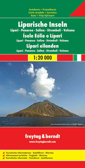
Aeolian (Lipari) Islands at 1:20,000 from Freytag & Berndt on a double-sided map which presents on the reverse coverage of Italy south of Rome at 1:600,000 and shows ferry access to the islands from the mainland or Sicily.On one side the islands are shown in a series of panels, with the three largest: Salina, Lipari and Vulcano together, and...Read more
Aeolian (Lipari) Islands at 1:20,000 from Freytag & Berndt on a double-sided map which presents on the reverse coverage of Italy south of Rome at 1:600,000 and shows ferry access to the islands from the mainland or Sicily.On one side the islands are shown in a series of panels, with the three largest: Salina, Lipari and Vulcano together, and...Read more
Deze kaart is ideaal voor het uitstippelen van wandel- en fietsroutes en om onderweg te gebruiken; goed leesbare kaart met heel veel topografische details; duidelijke symbolen maken de kaart extra overzichtelijk; wandel- en fietsroutes zijn aangegeven; praktische informatie over de regio; bruikbaar met GPS; nuttige informatie voor fietsers en...Read more
Deze kaart is ideaal voor het uitstippelen van wandel- en fietsroutes en om onderweg te gebruiken; goed leesbare kaart met heel veel topografische details; duidelijke symbolen maken de kaart extra overzichtelijk; wandel- en fietsroutes zijn aangegeven; praktische informatie over de regio; bruikbaar met GPS; nuttige informatie voor fietsers en...Read more
A chart for 2016 covering the south coast of Sicily and Malta Passage Plans included: Licata (1:20 000) Porto Palo and Capo Passero (1:100 000) Siracusa (1:35 000) Grand Harbour & Marsamxett (Malta) (1:15 000)Read more
Passage ChartsC0 Mallorca to Sicily 1:1,750,000C1 Sardinia 1:650,000C2 Sardinia North 1:350000C3 Sardinia East 1:350,000Coastal ChartsC4 Strait of Bonifacio 1:150,000C5 Porto Cervo to Capo Camino 1:150,000C6 Capo Camino to Capo Bellavista 1:150,000C7 Capo Bellavista to Capo Ferrato 1:150,000C8 Capo Ferrato to Capo Spartivento 1:150,000C9 Strait...Read more