
De Zwerver
Netherlands
- Wandelkaart 2458 Firenze - Siena - Chianti | Kompass
- Florence - Siena - Chianti area on a double-sided map at 1:50,000 from Kompass, printed on durable, waterproof and tear-resistant synthetic paper. Coverage includes Val di Pesa, Val d’Elsa, Monteriggioni, etc. Contours are at 40m intervals, with a 2-km UTM grid. Extensive overprint includes GEA - Grande Escursione Appenninica, Sentiero Italia,... Read more

Stanfords
United Kingdom
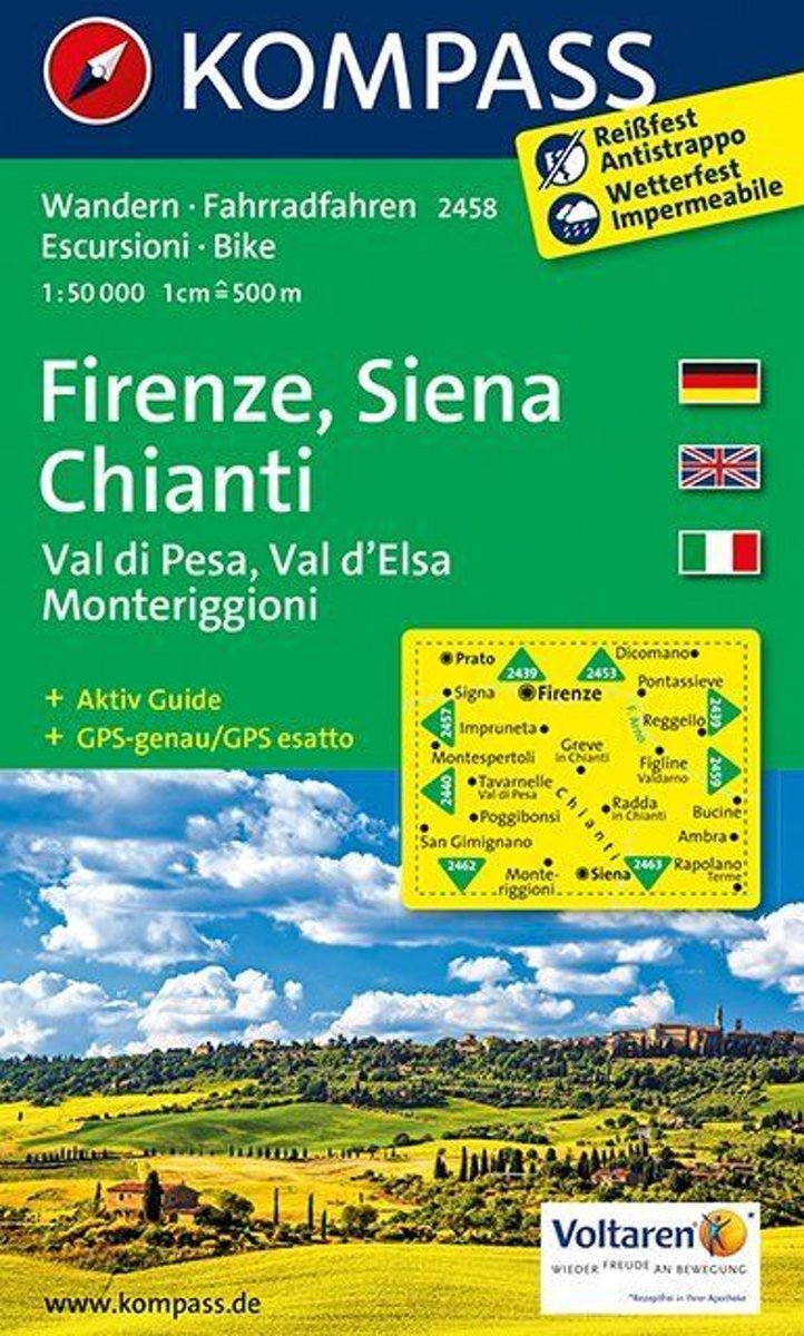
- Florence - Siena - Chianti Kompass 2458
- Florence - Siena - Chianti area on a double-sided map at 1:50,000 from Kompass, printed on durable, waterproof and tear-resistant synthetic paper. Coverage includes Val di Pesa, Val d’Elsa, Monteriggioni, etc. Contours are at 40m intervals, with a 2-km UTM grid. Extensive overprint includes GEA - Grande Escursione Appenninica, Sentiero Italia,... Read more
Bol.com
Netherlands
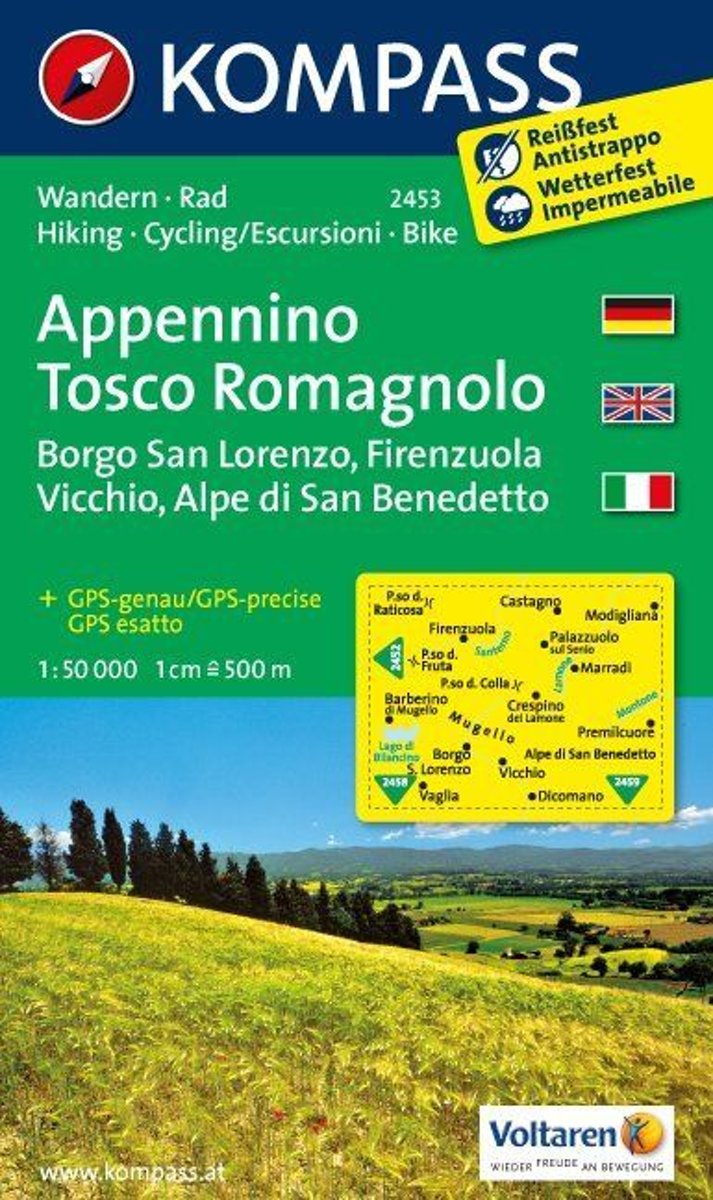
- Appennino Tosco-Romagnolo WK2453
- Deze kaart is ideaal voor het uitstippelen van wandel- en fietsroutes en om onderweg te gebruiken • goed leesbare kaart met heel veel topografische details • duidelijke symbolen maken de kaart extra overzichtelijk • wandel- en fietsroutes zijn aangegeven • praktische informatie over de regio • bruikbaar met GPS • nuttige informatie voor... Read more
Bol.com
Belgium
- Appennino Tosco-Romagnolo WK2453
- Deze kaart is ideaal voor het uitstippelen van wandel- en fietsroutes en om onderweg te gebruiken • goed leesbare kaart met heel veel topografische details • duidelijke symbolen maken de kaart extra overzichtelijk • wandel- en fietsroutes zijn aangegeven • praktische informatie over de regio • bruikbaar met GPS • nuttige informatie voor... Read more
Bol.com
Netherlands
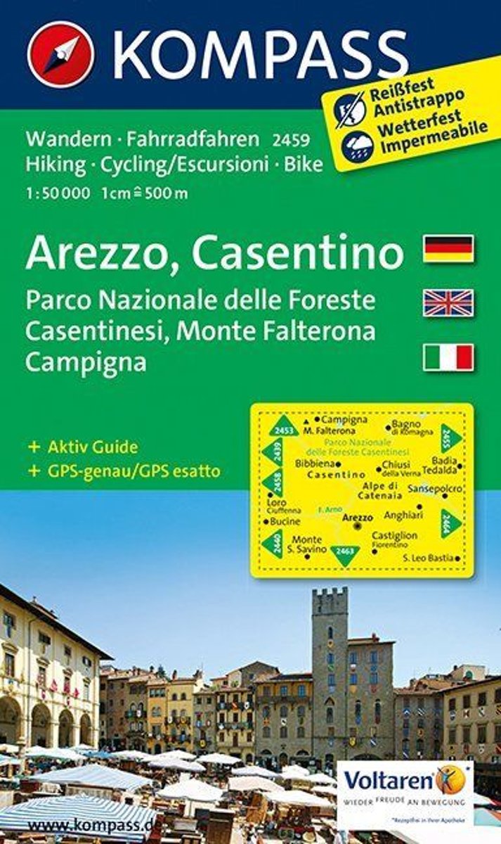
- Arezzo, Casentino WK 2459
- Deze kaart is ideaal voor het uitstippelen van wandel- en fietsroutes en om onderweg te gebruiken • goed leesbare kaart met heel veel topografische details • duidelijke symbolen maken de kaart extra overzichtelijk • wandel- en fietsroutes zijn aangegeven • praktische informatie over de regio • bruikbaar met GPS • nuttige informatie voor... Read more
Bol.com
Belgium
- Arezzo, Casentino WK 2459
- Deze kaart is ideaal voor het uitstippelen van wandel- en fietsroutes en om onderweg te gebruiken • goed leesbare kaart met heel veel topografische details • duidelijke symbolen maken de kaart extra overzichtelijk • wandel- en fietsroutes zijn aangegeven • praktische informatie over de regio • bruikbaar met GPS • nuttige informatie voor... Read more
Bol.com
Netherlands
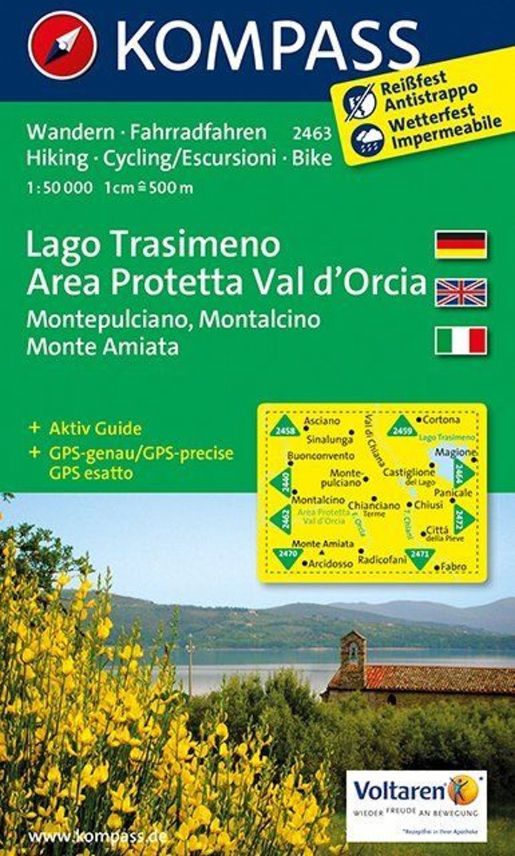
- Lago Trasimeno, Areo Protetta, Val d'Orcia WK2463
- Deze kaart is ideaal voor het uitstippelen van wandel- en fietsroutes en om onderweg te gebruiken • goed leesbare kaart met heel veel topografische details • duidelijke symbolen maken de kaart extra overzichtelijk • wandel- en fietsroutes zijn aangegeven • praktische informatie over de regio • bruikbaar met GPS • nuttige informatie voor... Read more
Bol.com
Belgium
- Lago Trasimeno, Areo Protetta, Val d'Orcia WK2463
- Deze kaart is ideaal voor het uitstippelen van wandel- en fietsroutes en om onderweg te gebruiken • goed leesbare kaart met heel veel topografische details • duidelijke symbolen maken de kaart extra overzichtelijk • wandel- en fietsroutes zijn aangegeven • praktische informatie over de regio • bruikbaar met GPS • nuttige informatie voor... Read more
Bol.com
Netherlands
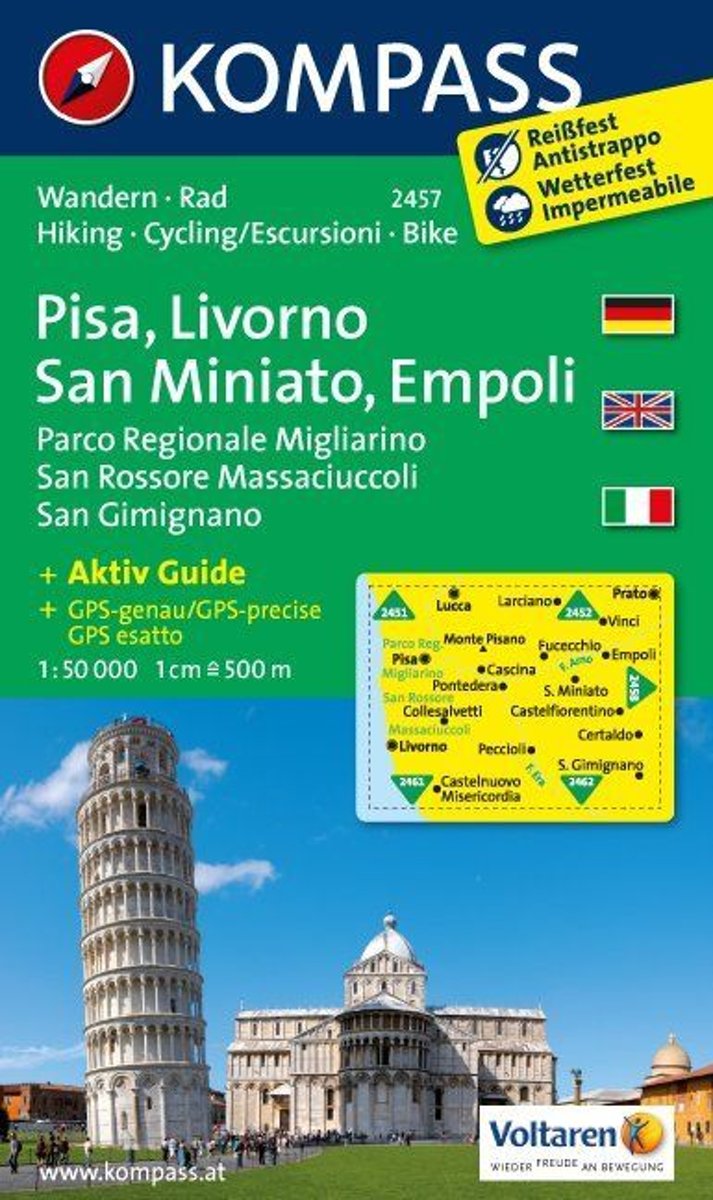
- Pisa, Livorno, San Miniato, Empoli WK2457
- Deze kaart is ideaal voor het uitstippelen van wandel- en fietsroutes en om onderweg te gebruiken • goed leesbare kaart met heel veel topografische details • duidelijke symbolen maken de kaart extra overzichtelijk • wandel- en fietsroutes zijn aangegeven • praktische informatie over de regio • bruikbaar met GPS • nuttige informatie voor... Read more
- Also available from:
- Bol.com, Belgium
- Stanfords, United Kingdom
» Click to openBol.com
Belgium
- Pisa, Livorno, San Miniato, Empoli WK2457
- Deze kaart is ideaal voor het uitstippelen van wandel- en fietsroutes en om onderweg te gebruiken • goed leesbare kaart met heel veel topografische details • duidelijke symbolen maken de kaart extra overzichtelijk • wandel- en fietsroutes zijn aangegeven • praktische informatie over de regio • bruikbaar met GPS • nuttige informatie voor... Read more

Stanfords
United Kingdom
- Pisa - Livorno - San Miniato - Empoli Kompass 2457
- Pisa - Livorno - San Miniato - Empoli area on a double-sided map at 1:50,000 from Kompass, printed on durable, waterproof and tear-resistant synthetic paper. Coverage includes Parco Regionale Migliarino - San Rossore – Massaciuccolli. Contours are at 40m intervals, with a 2-km UTM grid. Extensive overprint includes GEA - Grande Escursione... Read more
Bol.com
Netherlands
- Florence, Siena, Chianti WK2458
- Deze kaart is ideaal voor het uitstippelen van wandel- en fietsroutes en om onderweg te gebruiken • goed leesbare kaart met heel veel topografische details • duidelijke symbolen maken de kaart extra overzichtelijk • wandel- en fietsroutes zijn aangegeven • praktische informatie over de regio • bruikbaar met GPS • nuttige informatie voor... Read more
Bol.com
Belgium
- Florence, Siena, Chianti WK2458
- Deze kaart is ideaal voor het uitstippelen van wandel- en fietsroutes en om onderweg te gebruiken • goed leesbare kaart met heel veel topografische details • duidelijke symbolen maken de kaart extra overzichtelijk • wandel- en fietsroutes zijn aangegeven • praktische informatie over de regio • bruikbaar met GPS • nuttige informatie voor... Read more

Stanfords
United Kingdom
- Alta Valle del Lamone 22
- Map No. 22, Alta Valle del Lamone: Alto Appennino Faentino – Anello di Marradi, in series of contoured, GPS compatible hiking maps at 1:25,000 from the Istituto Geografico Adriatico, covering mainly the spine of the Apennines along the borders of Tuscany, Emilia-Romagna, Umbria and the Marches.Map in this series have contours at 25m intervals... Read more

Stanfords
United Kingdom
- Foreste Casentinesi NP Monti Editore 20
- Map No. 20, Foreste Casentinesi: Campigna, Camaldoli, Chiusi dell Verna, in series of contoured, GPS compatible hiking maps at 1:25,000 from the Istituto Geografico Adriatico, covering mainly the spine of the Apennines along the borders of Tuscany, Emilia-Romagna, Umbria and the Marches.Map in this series have contours at 25m intervals with... Read more

Stanfords
United Kingdom
- Riviera Cesenate - San Marino
- Map No. 128, Riviera Cesenate - San Marino, in a series of GPS compatible hiking maps at 1:50,000 from the Istituto Geografico Adriatico, covering parts of central Italy: eastern Tuscany, with northern Umbria and the Marches, plus the south-eastern of part of Emilia-Romagna.The maps have contours at 50m intervals with additional shading and... Read more

Stanfords
United Kingdom
- Gruppi Argentera e Marguareis Edizioni Multigraphic 109/115
- Gruppi Argentera e Marguareis, map no. 109/115 at 1:25,000 from Edizioni Multigraphic covering the Italian Alps along the southern part of the border between Piedmont and France, south of Cuneo. Coverage includes the Pallanfre Reserve, Colle di Tenda / Col de Tende, and Parco Naturale Valle Pesio. Map corners give latitude and longitude based... Read more
Stanfords
United Kingdom
- Colline di Rimini
- Map No. 124, Colline di Rimini, in a series of GPS compatible hiking maps at 1:50,000 from the Istituto Geografico Adriatico, covering parts of central Italy: eastern Tuscany, with northern Umbria and the Marches, plus the south-eastern of part of Emilia-Romagna. This title covers the holiday resorts on the Adriatic coast around Rimini,... Read more
Stanfords
United Kingdom
- Alta Val Marecchia
- Map No. 126, Alta Val Marecchia, in a series of GPS compatible hiking maps at 1:50,000 from the Istituto Geografico Adriatico, covering parts of central Italy: eastern Tuscany, with northern Umbria and the Marches, plus the south-eastern of part of Emilia-Romagna.The maps have contours at 50m intervals with additional shading and numerous spot... Read more

Stanfords
United Kingdom
- Lake Trasimeno - Val d`Orcia - Montepulciano - Monte Amiata Kompass 2463
- Lake Trasimeno - Val d`Orcia - Montepulciano - Monte Amiata area on a double-sided map at 1:50,000 from Kompass, printed on durable, waterproof and tear-resistant synthetic paper. Coverage includes Val di Chiana, Cortona, Montalcino, Asciano, Arcidosso, Fabro, Magione, etc. Contours are at 40m intervals, with a 2-km UTM grid. Extensive... Read more

Stanfords
United Kingdom
- Arezzo - Casentino - Foreste Casentinesi NP - Monte Falterona Kompass 2459
- Arezzo - Casentino - Monte Falterona map at 1:50,000 from Kompass, printed on durable, waterproof and tear-resistant synthetic paper. Coverage includes Foreste Casentinesi National Park. Contours are at 40m intervals, with a 2-km UTM grid. Extensive overprint includes GEA - Grande Escursione Appenninica, Sentiero Italia, etc, plus cycling and... Read more
Stanfords
United Kingdom
- Alta Valle del Metauro: Valle del Candigliano, Monte Nerone, Monte Catria
- Map No. 122, Alta Valle del Metauro: Valle del Candigliano, Monte Nerone, Monte Catria, in a series of GPS compatible hiking maps at 1:50,000 from the Istituto Geografico Adriatico, covering parts of central Italy: eastern Tuscany, with northern Umbria and the Marches, plus the south-eastern of part of Emilia-Romagna.The maps have contours at... Read more