De Zwerver
Netherlands
De Zwerver
Netherlands
» Click to open
Stanfords
United Kingdom
  • Longwy - Longuyon IGN 3211SB
  • Topographic survey of France at 1:25,000 in IGN`s excellent TOP25 / Série Bleue series. All the maps are GPS compatible, with a 1km UTM grid plus latitude and longitude lines at 5’ intervals. Contours are at 5m intervals except for mountainous areas where the maps have contours at 10m intervals, vividly enhanced by hill shading and graphics for... Read more
» Click to close
De Zwerver
Netherlands
» Click to open
Stanfords
United Kingdom
  • Mirecourt - Charmes IGN 3417SB
  • Between 2014 and 2019, the IGN renewed its entire Serie Bleue collection. A new map for optimal readability, with better geometric precision and enriched tourist information. A new format twice as large: the format of the new Serie Bleue is equivalent to that of the Top 25 and the number of references will thus be divided by 2. For most maps,... Read more
» Click to close
De Zwerver
Netherlands
» Click to open
Stanfords
United Kingdom
  • Metz - Courcelles-Chaussy IGN 3413SB
  • Topographic survey of France at 1:25,000 in IGN`s excellent TOP25 / Série Bleue series. All the maps are GPS compatible, with a 1km UTM grid plus latitude and longitude lines at 5’ intervals. Contours are at 5m intervals except for mountainous areas where the maps have contours at 10m intervals, vividly enhanced by hill shading and graphics for... Read more
» Click to close
De Zwerver
Netherlands
» Click to open
Stanfords
United Kingdom
  • Ste-Marie-aux-Mines - PNR des Ballons des Vosges IGN WATERPROOF 3617ETR
  • Topographic survey of France at 1:25,000 in IGN`s excellent TOP25 / Série Bleue series. All the maps are GPS compatible, with a 1km UTM grid plus latitude and longitude lines at 5’ intervals. Contours are at 5m intervals except for mountainous areas where the maps have contours at 10m intervals, vividly enhanced by hill shading and graphics for... Read more
» Click to close
De Zwerver
Netherlands
2015
» Click to open
Stanfords
United Kingdom
2015
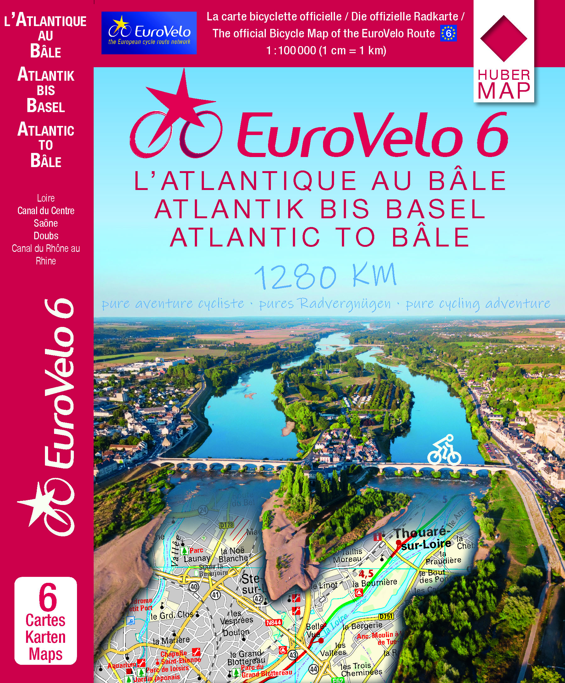
  • EuroVelo 6 - Atlantic to Basel 6-Map Set
  • EuroVelo Route No. 6 in a six-map set covering the French part of this trans-European cycle route: from the Atlantic along the Loire, the Canal du Centre, the Saône, the Doubs and the Canal du Rhône au Rhin to the Rhine at Basel. The route is presented on six double-sided, GPS compatible maps at 1:100,000 published by Huber Verlag with funding... Read more
» Click to close
De Zwerver
Netherlands
2014
» Click to open
Stanfords
United Kingdom
2014
  • Mercantour & Alpi-Marittime Didier Richard 07
  • Mercantour National Park and the Maritime Alps on a large, double-sided, contoured and GPS compatible map from Editions Didier Richard highlighting local walking trails and long-distance hiking routes including the GR5. Coverage extends from well north of Col de Larch to Sospel, Levens and Roquestéron in the mountains north of the French... Read more
» Click to close
De Zwerver
Netherlands
2024
De Zwerver
Netherlands
De Zwerver
Netherlands
» Click to open
Stanfords
United Kingdom
  • Alsace - Strasbourg - Saverne - Barr - Offenburg K+F Outdoor Map 7
  • The central part of Alsace around Strasbourg and Saverne on a GPS compatible, double-sided map at 1:50,000 from Kümmerly+Frey printed on sturdy, waterproof and tear-resistant synthetic paper; contoured, with hiking and cycling routes, sites for other recreational activities, various accommodation options, restaurants and ferme-auberge... Read more
» Click to close
De Zwerver
Netherlands
2024
De Zwerver
Netherlands
» Click to open
Stanfords
United Kingdom
  • Bischwiller - Brumath IGN 3815SB
  • Between 2014 and 2019, the IGN renewed its entire Serie Bleue collection. A new map for optimal readability, with better geometric precision and enriched tourist information. A new format twice as large: the format of the new Serie Bleue is equivalent to that of the Top 25 and the number of references will thus be divided by 2. For most maps,... Read more
» Click to close
De Zwerver
Netherlands
» Click to open
Stanfords
United Kingdom
  • Pont-a-Mousson - Thiaucourt-Regnieville IGN 3314SB
  • Topographic survey of France at 1:25,000 in IGN`s excellent TOP25 / Série Bleue series. All the maps are GPS compatible, with a 1km UTM grid plus latitude and longitude lines at 5’ intervals. Contours are at 5m intervals except for mountainous areas where the maps have contours at 10m intervals, vividly enhanced by hill shading and graphics for... Read more
» Click to close
De Zwerver
Netherlands
» Click to open
Stanfords
United Kingdom
  • Nancy - Epinal - Vallee de la Moselle IGN TOP100 121
  • Discover the new double-sided laminated edition of TOP100 road maps of France from the Institut Géographique National (IGN); exceptionally detailed, contoured road maps which include the cycle paths and greenways of the AF3V (French Association for the Development of Cycle Paths and Greenways), ideal for exploring the French countryside by car,... Read more
» Click to close
De Zwerver
Netherlands
2024