Reykjavegur
Beschrijving
- Name Reykjavegur
- Lengte van pad 114 km, 71 mijl
- Lengte in dagen 7 dagen
- Start van pad Reykyanesviti lighthouse
- Einde van pad Nesjavellir power station
- Traildino graad MW, Gemiddelde wandeling, trektocht
- Huttentrektocht graad T1, Wandeling
Reykjanesviti (lighthouse) – Nesjavellir, 114 km, 7 days
This hike is situated near the capital of Reykjavík. The start is at the lighthouse Rykjanesviti at the western tip of the Reykjanes peninsula, not far from Keflavík international airport. The proximity of Reykjavík in no way means that this is a busy area. On the contrary: the chance that you will meet other hikers is not great.
The entire route is marked with blue sticks, and at regular distances you will find water and toilets. You must bring your own tent. You will not run into shops of course, but you will pass three through roads three times that may brings you to Reykjavík if you wish. Moreover, at the end of day one you will arrive at the Blue Lagoon, and after a soothing bath in the natural hot mineral rich water you can move into your hotel room. The easy way!
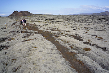
The landscape is undulating, bald hills, with thick mossy surfaces, bare sandy and stony plains, hills in shades of black and blue. This hike comes with a guidebook and maps, for sale in the local shops.


